Geomatics Tutoring: Boosting Spatial Learning and Homework Help

Geomatics tutoring provides students personalized support in surveying, GIS, and mapping. Expert online tutors demystify complex spatial topics, making learning more engaging and improving grades at their own pace.
Understanding Geomatics
Geomatics is the study of gathering, storing, and analyzing geographic data. It covers surveying, mapping, GPS, remote sensing, and GIS systems. According to ISO standards, geomatics involves the collection and management of geospatial information. In practical terms, geomatics combines math, computer science, and earth science to describe our world. A geomatics teacher or professor might cover topics like map projections, coordinate systems, and 3D modeling to show how complex projects are planned and built.
To visualize how these diverse fields come together, look at the intersection of these three core disciplines.
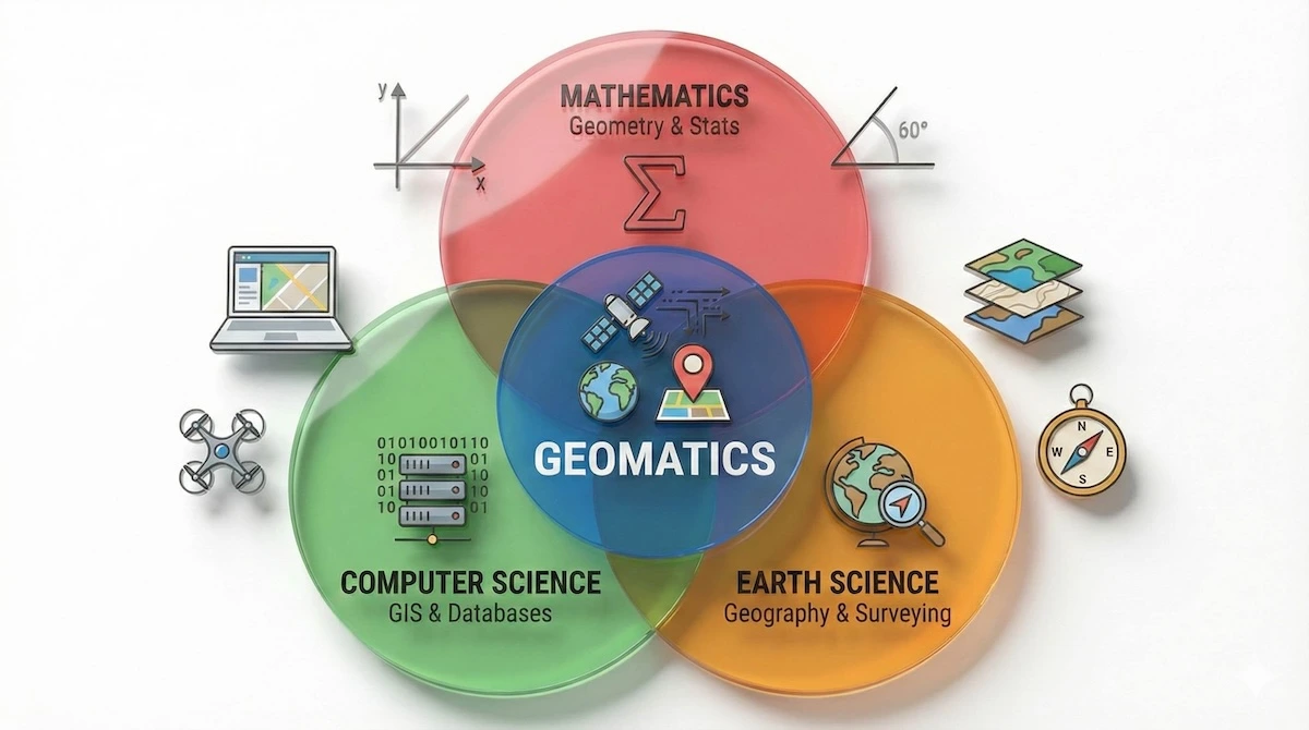
Geomatics sits at the intersection of math, technology, and earth science, blending these fields to map our world accurately.
As you can see, Geomatics isn’t just one subject—it’s the ‘sweet spot’ where data analysis, spatial reasoning, and technology meet.
In hands-on labs, students often use total stations, drones, or GIS software to capture real-world data. For example, Georgia Tech students use advanced Leica surveying equipment to map terrain. As one professor noted, “as infrastructure systems become more complex, the ability to monitor and map using these geospatial technologies becomes even more important”. In the words of a geomatics professor, “everything we build or monitor on Earth requires precise spatial coordinates,” highlighting geomatics’ role in engineering and planning.
Why Geomatics Matters
Geomatics skills are in high demand across industries. Civil engineering, construction, environmental science, and even urban planning rely on geomatics for accurate maps and data. Geospatial technology underpins GPS navigation, satellite imaging, and autonomous vehicles. One university program notes that “Geomatics is making a resurgence” with job opportunities described as “plentiful and expanding”. In the U.S., employment of surveying and mapping technicians is projected to grow 5% from 2024 to 2034, which is faster than average. This growth reflects a need for more technicians and engineers who understand geomatics.
Is this career path worth the effort? The market data paints a very clear picture of the financial potential.
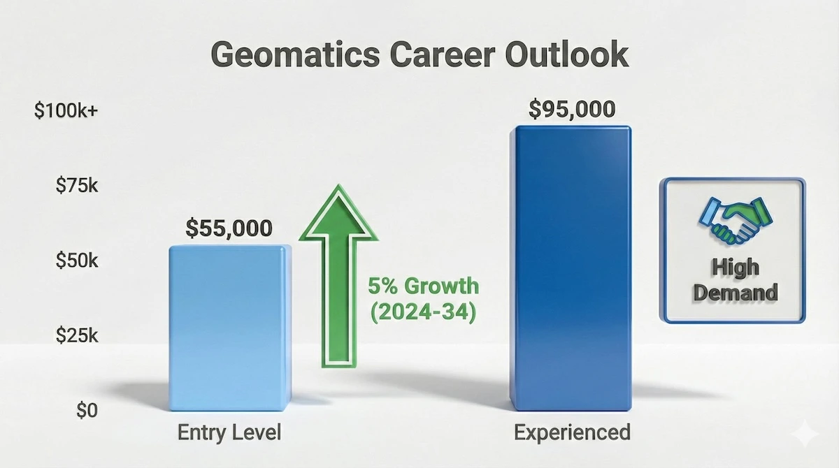
With salaries starting strong and job growth outpacing the average, mastering Geomatics offers excellent return on investment.
With steady growth and strong entry-level salaries, mastering these skills now is a direct investment in your future financial stability.
However, experts also warn of a workforce gap. A shortage of trained geomatics professionals could slow infrastructure and technology projects. For students, this means mastering geomatics can open doors: even entry-level careers in surveying and GIS often pay around $50,000–$60,000 per year. With demand high and talent scarce, students who excel in geomatics are likely to find good job prospects.
Challenges in Geomatics Learning
Geomatics combines advanced math, technology, and fieldwork, so it can be challenging for students. High school and college courses assume a strong background in geometry, algebra, and physics, and also introduce specialized software like CAD or ArcGIS. Without extra support, topics like converting coordinates or processing LiDAR scans can feel overwhelming. In many schools, a dedicated geomatics teacher is rare, so students may only see parts of geomatics in other classes. This gap can make assignments or projects feel daunting, which is when many turn to Online tutoring services or homework help services.
Why do students struggle in lecture halls but thrive with tutors? The difference lies in the learning environment.
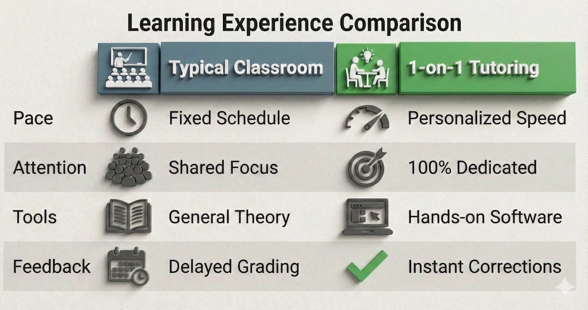
While classrooms provide the theory, one-on-one tutoring offers the personalized pace and instant feedback critical for mastering complex tools.
By switching from a passive classroom listener to an active participant, you close the gap between theory and application.
How Geomatics Tutoring Helps
Personalized tutoring bridges the gap between classroom teaching and understanding. Tutors provide one-on-one attention that classes often cannot. They adapt explanations to a student’s level, replay concepts until clear, and use real-world examples. Research shows that tutoring is a highly effective educational strategy. A landmark study found one-on-one tutoring to be “one of the most effective tools for enhancing educational outcomes”. Similarly, a systematic review found that tutoring yields “consistent and substantial positive impacts” on learning outcomes. In other words, targeted tutoring in a difficult subject like geomatics can significantly boost a student’s performance.
Many tutoring companies even advertise quick-turnaround support labeled as “Geomatics hw help” (homework help), where students submit questions or assignment parts and get prompt guidance from experts. These services complement regular tutoring by solving specific problems or reviewing homework steps.
Benefits of Geomatics Tutoring
Hiring a Geomatics tutor or using online tutoring offers many advantages:
- Customized learning: Tutors tailor lessons to each student’s needs and pace, focusing on troublesome concepts like coordinate math or GIS software.
- Interactive tools: Many tutors use real examples and software (like GIS, CAD, or drone data) to make learning hands-on and clear.
- Homework and assignment help: Students get step-by-step guidance on Geomatics projects, from plotting maps to survey data analysis.
- Flexible support: Online sessions mean help is available after school or from home, ensuring concepts are understood before exams.
- Proven results: Studies find that students receiving tutoring see significant gains in understanding and grades.
Online Geomatics Tutoring
Online tutoring has made geomatics education more accessible than ever. A student in any country—USA, UK, Gulf countries, etc.—can now connect with a qualified tutor. In fact, STEM subjects like GIS and surveying drove the online tutoring market: STEM courses accounted for the largest share of online tutoring services in 2024. Through video chats and shared screens, a Geomatics tutor online can demonstrate how to use GIS software or solve math problems in real time. This means a remote learner gets much the same benefit as an in-person lesson, often at a lower cost. According to industry analysts, the global online tutoring market was about $10.4 billion in 2024 and is projected to more than double by 2030, reflecting high demand for subjects like geomatics.
If you’re wondering how a practical subject like this works remotely, here is the typical workflow for an online session.
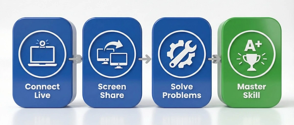
Modern online tutoring uses screen sharing and real-time problem solving to replicate the in-person lab experience from anywhere.
This interactive loop—seeing, doing, and correcting instantly—is often more effective than watching a pre-recorded lecture.
Many platforms offer interactive tools specifically for geomatics: tutors can share mapping screens or even drone images during lessons. Parents and students in regions like the Middle East (Gulf countries), Europe, and the UK especially appreciate online geomatics tutoring to meet growing engineering standards. Overall, the convenience of flexible scheduling and a wide tutor selection make online learning a popular choice for Geomatics students of all ages.
Choosing a Geomatics Tutor or Teacher
When hiring a Geomatics tutor, look at credentials and experience. Ideally, a tutor has a background in surveying, GIS, or a related engineering field. Some tutors are professional surveyors or GIS analysts. Ask about their experience and if they have helped other students with similar courses. Many services offer trial sessions so you can gauge their teaching style. Fees often range from about $20–$40 per hour (higher for very specialized expertise or rush sessions). Keep in mind that this investment can pay off in better grades and easier project work.
Here are some tips for finding the right tutor:
- Verify the tutor’s qualifications (e.g., surveying certification, GIS experience, or engineering degree).
- Check if they have classroom teaching or industry experience relevant to your curriculum.
- Read reviews or get recommendations to ensure they have a clear teaching style.
- Ensure they cover the topics you need, such as map analysis, CAD skills, or geomatics assignment help.
- Confirm their availability and whether their rates ($20–$40/hour) fit your budget.
Ready to hire someone? Use this quick decision checklist to screen potential tutors effectively.
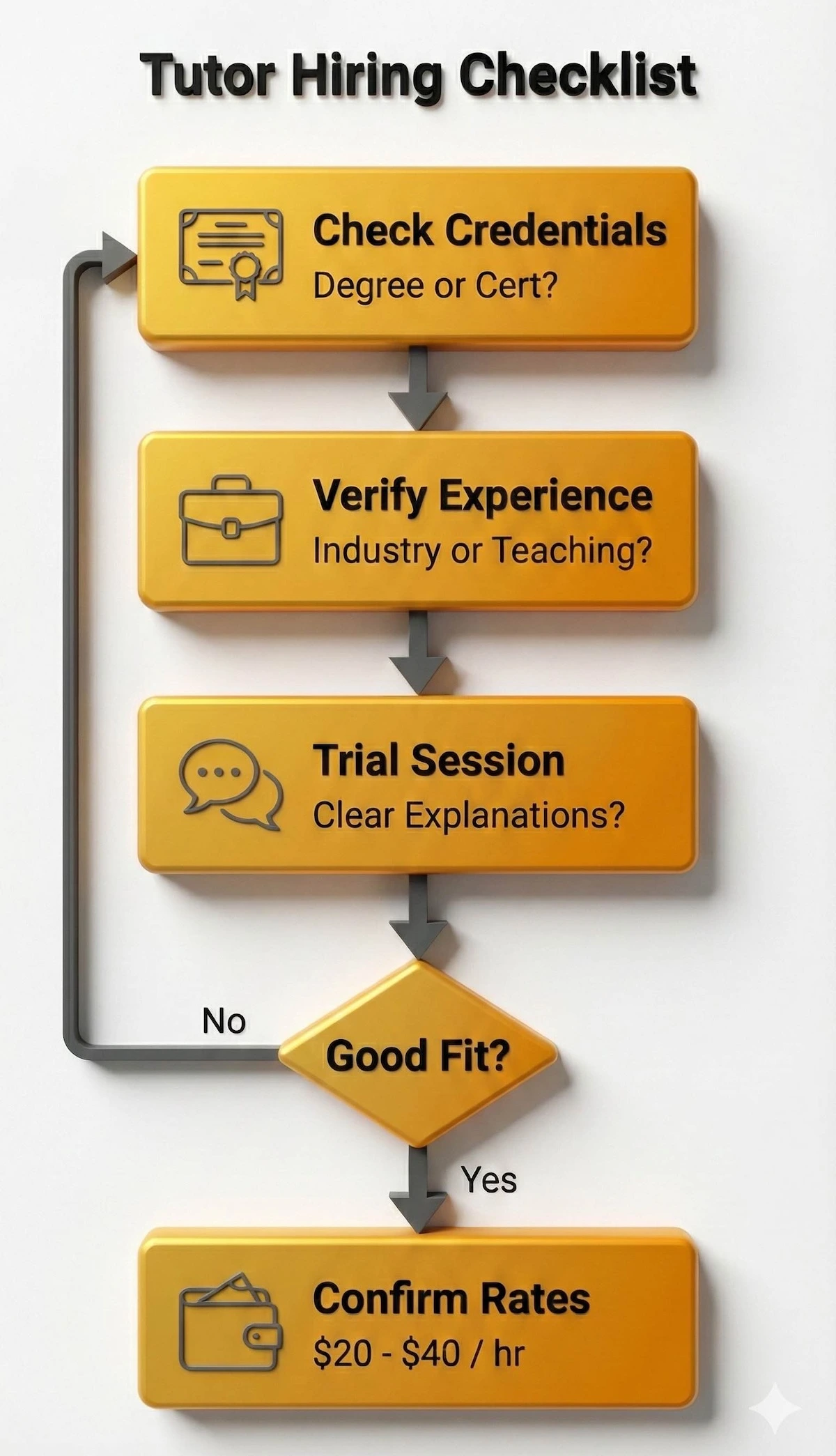
Follow this simple checklist to ensure you find a qualified tutor who matches your specific learning needs and budget.
Following these four steps will help you avoid inexperienced tutors and ensure you get value for every dollar spent.
If your school offers a Geomatics course, the classroom teacher covers general topics, but a tutor can reinforce those lessons. If your child needs help with geomatics homework or a specific project, hiring a tutor (or “hiring a Geomatics tutor” online) can provide that extra attention. You can find tutors through local college job boards, professional societies, or online tutoring platforms that specialize in STEM subjects.
Real-Life Success Stories
Imagine a freshman struggling with his first surveying lab. Concepts like leveling or calculating angles confused him. He found an online Geomatics tutor who used real field data to teach the concepts step by step and helped him with his exam prep. Over a few weeks, his understanding grew. By the next exam, he was solving survey problems confidently and raising his scores. Another high school senior named Sara improved her grade from a C to an A on a geomatics project after getting focused assignment help. These one-on-one tutoring sessions provide support that classroom time often can’t, turning frustration into achievement.
Across the globe—from high school students in the UK plotting contour maps to college cadets in Gulf nations analyzing GIS data—tutoring fills gaps and reinforces learning. Online geomatics tutors make it easy to connect with experts anywhere, so distance or limited local resources are no longer barriers. With practice and guidance, many learners find that geomatics becomes not only manageable but even engaging and fun.
Ultimately, getting help early can prevent students from falling behind. By investing in expert guidance, learners can turn a challenging course into a rewarding experience.
Frequently Asked Questions
- What is a Geomatics tutor? A Geomatics tutor is an expert in surveying, GIS, and mapping who provides one-on-one support to help students understand those topics.
- Who can benefit from Geomatics tutoring? Any student struggling with geospatial courses or wanting advanced help (in high school or college) can improve with a Geomatics tutor.
- Is Geomatics tutoring available online? Yes, many tutors offer online sessions via video chat, making Geomatics tutoring online accessible from anywhere.
- What subjects does a Geomatics tutor cover? Tutors can assist with surveying, GIS, photogrammetry, remote sensing, and related topics, providing help on assignments and projects.
- How much does Geomatics tutoring cost? Rates vary, but many tutors charge between $20 and $40 per hour, depending on expertise and location.
- How do I hire a Geomatics tutor? You can hire a Geomatics tutor through educational platforms or tutoring agencies; look for reviews and credentials to find a good match.
Related subjects:
ArcGIS and ArcGIS Pro
Geodesy
Geographic Information System (GIS)
Photogrammetry
QGIS
Remote Sensing
******************************
This article provides general educational guidance only. It is NOT official exam policy, professional academic advice, or guaranteed results. Always verify information with your school, official exam boards (College Board, Cambridge, IB), or qualified professionals before making decisions. Read Full Policies & Disclaimer , Contact Us To Report An Error